
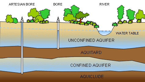
Relationships between components of a groundwater system
Groundwater is the term referring to water that occurs under the ground. Groundwater is a vast and slow moving resource that greatly exceeds the volume of other available freshwater sources. The study of groundwater is known as hydrogeology.
Although the earth's surface might appear to be made of solid materials like rock, these are actually porous. Occupying the tiny spaces between particles, groundwater forms subterranean reservoirs.
The porosity of a substrate determines the amount of water it can contain and transmit. Highly porous substrates can contain and transmit larger volumes of water than those with low porosity.
An aquifer is a layer of relatively porous substrate that contains and transmits groundwater. When water can flow directly between the surface and the saturated zone of an aquifer, the aquifer is unconfined. Because water tends to flow downward due to gravity, the deeper parts of unconfined aquifers are usually more saturated with groundwater. The upper level of this saturated layer of an unconfined aquifer is called the water table.
Substrate with relatively low porosity that permits limited transmission of groundwater is known as an aquitard. An aquiclude is a substrate with porosity that is so low it is virtually impermeable to groundwater.
A confined aquifer is an aquifer that is overlain by a relatively impermeable layer of rock or substrate such as an aquiclude or aquitard. Confined aquifers are usually under pressure because they occur at depth from the surface and are compressed by the overlying confining rock and substrate. Groundwater that is under sufficient pressure to allow it to flow to the surface is referred to as artesian water.
Groundwater usually originates at the surface. Rainwater infiltrates the surface layers and percolates through the substrate to supply an aquifer. The flow of water into an aquifer is known as recharge.
Groundwater can also return to the surface. The level of the water table in an unconfined aquifer influences the volume of water in surface drainage channels that flow across it. When erosion removes overlying layers or cuts deeply into the earth's surface, the groundwater in aquifers can be brought closer to the surface. The deformation of aquifers and confining layers by geological processes can cause groundwater from aquifers water to flow from springs at the surface.
Where groundwater does not come to the surface naturally, it is usually obtained from the penetration of an aquifer by digging a well or bore. Water that flows from the surrounding saturated permeable substrate of the aquifer into space formed by the bore can then be pumped to the surface.

Facts curated by Dr Landon Halloran, Dr Gabriel Rau and Dr Martin Andersen from UNSW Sydney. Graphics and design by Anna Blacka from UNSW Sydney. Funded by the NSW Research Acceleration and Attraction Program to support the Australian Government National Collaborative Research Infrastructure Scheme.

This resource introduces aquitards and aquicludes, and discusses some of the cutting-edge approaches used to understand the movement of water and contaminants through the ground.

Having a geologically realistic conceptual site model is important for characterising hydraulic connectivity throughout aquifer systems, and modelling water transit times.

The use of heat as a tracer promises to be an excellent alternative to traditional assessment methods for quantifying exchange between surface water and ground water.

There are two common mistakes often made when calculating how much groundwater storage levels have changed.