

The Namoi valley contains some of the best agricultural soils in Australia. Concern about the reliability of the underlying groundwater resources has become a contested Political area as the pressure to develop coal-seam gas, open-cast coal and agriculture all play out in the political domain at a local, State and Federal level. The GEIF project has sort to develop a much improved understanding of the links between surface water and groundwater in the Maules Creek area, drained by one of the tributary streams of the Namoi.
A profile of double piezometers has been installed on the banks of the Namoi, close to the Maules Creek confluence, to better understand the transfer of water, both to and from the Namoi, in response to natural floods, dam releases and groundwater pumping from adjacent abstraction bores. Dr Martin Andersen (CWI, UNSW) is leading up this work and is collaborating with Dr Denis O’Carroll (University of Western Ontario, Canada). Gabriel Rau, Anna Greve and Andrew McCallum have all completed successful PhD theses on this work.
The Upper Maules Creek area is characterised by stretches of both losing and gaining groundwater. Semi-permanent groundwater discharge around Elfin Crossing has been studied by Dr Gabriel Rau (CWI, UNSW) using heat as a tracer. This work commenced using Cotton CRC funding and has been further developed using GEIF funds to better understand the boundary conditions to this system. Dr Mark Cuthbert (Marie Curie EEC Post Doc from Birmingham University) is working on the stretch above Elfin Crossing where surface water flowing down Maules Creek from rainfall around Mount Kaputar frequently drains into the underlying aquifer under losing conditions. GEIF funds have been used to better instrument this part of the catchment and to provide semi-permanent monitoring of the system.
The Cockburn River catchment has been drilled and instrumented using GEIF funds in a project led by Prof Peter Cook (Flinders, NCGRT)
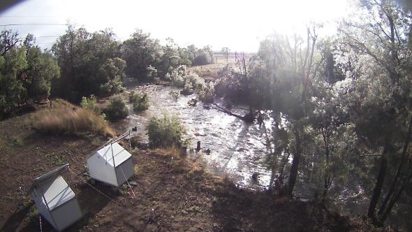 Automated camera shot at East Lynne during a flow event in Middle Creek. The solar powered huts in the foreground house auto samplers and data loggers for borehole and in-creek monitoring.
Installation of a new Mountain Front Hydrological Observatory (MFHO), funded under the Groundwater Education and Infrastructure Fund (GEIF), has recently been completed in the Maules Creek catchment in northern NSW.
Installed by staff from UNSW, the Connected Waters Initiative Research Centre (CWI) and Marie Curie Fellow Dr Mark Cuthbert from Birmingham University, UK, the MFHO is designed to enable a better understanding of the interactions between surface water and groundwater in a semi-arid region where ephemeral streams are the main source of groundwater recharge.
Rainfall run off from the steep Nandewar Mountains is focussed at the mountain front into a series of ephemeral creeks which leak into the underlying aquifer used extensively for cotton irrigation.
The new facility includes nested piezometers installed at various depths within boreholes located at different distances from the mountain front and from Middle Creek, an ephemeral tributary of Maules Creek. All the piezometers are equipped with data loggers to automatically record the groundwater levels and, in some places, also the groundwater chemistry.
A weather station has been installed alongside soil moisture probes for monitoring the background weather conditions and for estimating direct groundwater recharge by rain away from the creeks. The weather station automatically streams data back to UNSW.
Probes have been installed to monitor borehole and creek water levels and water chemistry as well take water samples throughout flow events for subsequent laboratory analysis. A series of water level recorders and temperature probes have also been installed in the creek bed along a 10 km reach of the creek. Using heat as a tracer, these will enable the timing of the wetting and drying of the creek bed, as well as the rates of water exchange between the creek and the underlying alluvial aquifer, to be determined.
The timing, rates and climate conditions which control the amount of recharge in these types of environments are notoriously hard to estimate and there is only a small number of field sites around the world which enable the hydrology of such systems to be studied in such detail. It is hoped that the data from the Maules Creek MFHO will enable better estimates to be made of how groundwater resources are renewed and how climate change might affect water availability in an already water-stressed area.
Much of the infrastructure is telemetered and the data can be viewed online at the Namoi Groundwater Data Portal.