
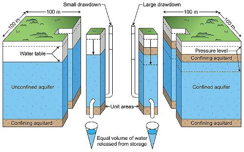
Differences in water level response to extraction in unconfined and confined aquifers.
Groundwater levels - and changes in those levels - are often used to gauge the volume of water stored in aquifers. Changes in groundwater levels can be used to calculate how much groundwater storage has increased due to recharge, or decreased due to discharge such as extraction for use.
However, there are a few tricks to interpreting the levels. There are two common mistakes often made when calculating how much groundwater storage levels have changed.
The first common mistake is to overestimate the volume of pore spaces that can be filled with water. There are only a few small areas of Australia that have vast caverns or caves, restricted to limestone deposits Groundwater storage is generally limited to small pore spaces in sands and gravels, and sometimes fractures in rocks.
For example, a sand aquifer contains 75% sand particles and 25% pore spaces. The available groundwater storage in a 10 metre thick aquifer, over an area of 100 metres by 100 metres (1 hectare), is not 100,000 m3 (or 100 ML). Groundwater storage is actually 25% of this volume, equivalent to 25,000 m3 (or 25 ML). That's less groundwater storage than you might think by a factor of four!
The second common mistake is not recognising the unique storage factors of aquifers when calculating storage changes from water level changes. Anyone can make this mistake if they haven't completed specialist groundwater training, even scientists and engineers!
Groundwater level behaviour is quite different for shallow aquifers (unconfined), and aquifers that are pressurised by the weight of water and sediment or rock that is above (confined). Confined aquifers are generally deeper aquifers, although in some environments, even aquifers within a few metres of the surface behave as confined aquifers.
The watertable is measured in a bore that draws from an unconfined aquifer. However, a groundwater pressure level is measured in a bore that draws from a confined aquifer. Let's look at how a watertable level and a pressure level respond to an equal loss of 1 ML from each of these two types of aquifer.
Type 1 - Water Level response in an Unconfined Aquifer
The unconfined aquifer losses 1 ML (or 1,000 m3) due to 100 mm of evapotranspiration by plants over an area of 100 x 100 m (picture on the left). The unique storage property of an unconfined aquifer is called a specific yield and is typically 0.25. This means that for 1 ML (or 100 mm) of storage loss, the water level is drawn down by 0.4 m (or 400 mm). The groundwater level response is in a way magnified by the aquifer.
Groundwater drawdown in unconfined aquifer (m) = groundwater storage loss (m) / specific yield
Type 2 - Water Level response in a Confined Aquifer
If a confined aquifer lost an equal volume of water (1 ML or 1,000 m3) due to extraction by pumping, the water level would fall much further (picture on the right). Again, the storage loss is equivalent to 0.1 m over an area of 100 x 100 m. This behaviour is due to the unique storage factor of a confined aquifer called storativity, that can be very small (0.01 or much smaller). This means that for storage loss of 1 ML, the groundwater level would be drawn down by 10 m or much more. The drawdown is relatively large compared to an unconfined aquifer.
Groundwater drawdown in confined aquifer (m) = groundwater storage loss (m) / storativity
Groundwater levels in confined aquifers are very sensitive to changes in storage. In reality, the storativity factor of confined aquifers can be as small as 10-6. Storage factors in confined aquifers are much lower because they are not drained during pumping and any water released from storage is obtained primarily by compression of the aquifer and expansion of the water when pumped.

Facts curated by Dr Landon Halloran, Dr Gabriel Rau and Dr Martin Andersen from UNSW Sydney. Graphics and design by Anna Blacka from UNSW Sydney. Funded by the NSW Research Acceleration and Attraction Program to support the Australian Government National Collaborative Research Infrastructure Scheme.

This resource introduces aquitards and aquicludes, and discusses some of the cutting-edge approaches used to understand the movement of water and contaminants through the ground.

Having a geologically realistic conceptual site model is important for characterising hydraulic connectivity throughout aquifer systems, and modelling water transit times.

The use of heat as a tracer promises to be an excellent alternative to traditional assessment methods for quantifying exchange between surface water and ground water.

There are two common mistakes often made when calculating how much groundwater storage levels have changed.