Posted 28 April 2008
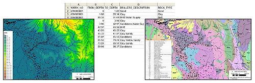
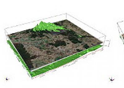
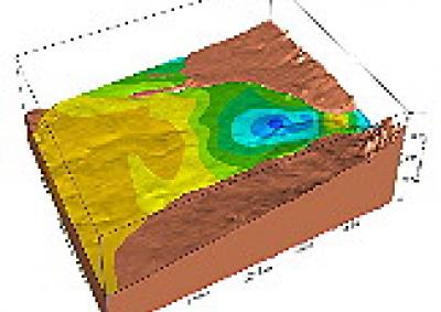
Digital elevation models (DEM, left), borehole spreadsheet data (centre), geological maps (right) can be combined to generate...
Enhancing our knowledge of hydrogeological processes, better scientific communication, cost-effective environmental solutions.
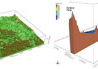
Three dimensional modelling of earth science data has expanded rapidly over the last decade, but further research and case studies are needed on how to best visualise multiple data sets and to characterise the uncertainty in our interpretation of the available information. The construction of these models is a blend of geological knowledge with computer science.
Traditionally, geologists and hydrogeologists have worked with 2D maps and cross sections between boreholes, to establish the distribution of geological layers and properties between the boreholes. How we collate and visualise data dramatically influences the way we perceive the world. Traditional 2D maps limit our capacity to visualise the complexity of our 3D world. Advances in 3D geological modelling software and data availability now enable the analysis and communication of complex geological and hydrological data sets in a visually interactive 3D environment.
Whether characterising the hydrogeology of a catchment or determining the extent of contaminated soil or water on an industrial site, 3D geological models combined with geostatistical methods can provide the hydrogeologist with methods to determine the most likely value of a property at non-sampled locations, quantify the uncertainty in that estimate, and subsequently guide the placement of additional boreholes or optimise expenditure on site characterisation.
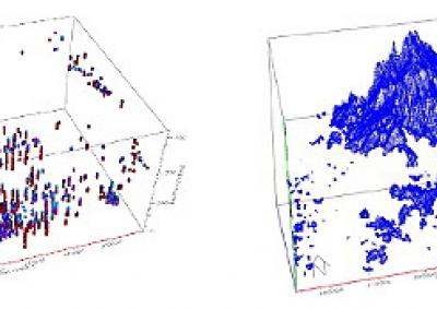
Earth science information for geological mapping and resource characterisation is obtained from many sources including satellite, land and airborne geophysical surveys, geological field mapping and borehole logging. Due to variations in the scale of data collection (including the density of the samples and the volume of the samples), original survey objects and measurement errors, data sets rarely combine cleanly in 3D space to give a unique interpretation of the hydrogeology.
The Connected Waters Initiative (CWI) are researching how to integrate all disparate earth science data relating to the hydrogeology of catchments in order to build improved frameworks for catchment water balance modelling. These 3D geological models will also lead to better scientific understanding of the processes surrounding coupled surface and ground water interactions.
3D geological models for all disciplines of the earth sciences
Although the focus of the CWI team is on 3D regional hydrogeological models, the methods are appropriate to most areas of the earth sciences where 3D visualisation and characterisation leads to improved understanding of processes, and better communication of complex 3D spatial information to managers and communities. Examples where enhanced knowledge of physical processes and communication of the scientific data benefit from 3D geological models include:
The possibilities of 3D data analysis are unlimited, so if you have 3D earth science data presentation and analysis problems contact us about collaborative research projects.
- 3D mapping groundwater contamination plumes
- Modelling of karst terrains in all their spatial complexity
- Mapping hydrocarbon traps in petroleum reservoirs
- Calculation of coal resources
- Defining traps for CO2 storage
- 3D ore reserve models
- Modelling the distribution of ocean currents
Advances in 3D geological modelling software and numerical methods have provided hydrogeologists with a toolbox of flexible methods to improve our capacity to estimate the value of physical and chemical properties in space at non-sampled locations. We are also better positioned to quantify the uncertainty in our estimate. Questions that we often need to answer include:
In the earth sciences we will never have enough data to eliminate uncertainty, but we can improve the way that we quantify the uncertainty and acknowledge that uncertainty in the way we manage an aquifer, or remediate contaminated land. Our research goals, led by Associate Professor Bryce Kelly, include:
Capturing the true 3D distribution of aquifer sediment types and their associated hydraulic properties is critical when coupling water chemistry and ecological processes to the movement of water movement through a catchment. The 3D models will yield improved insights on recharge pathways, groundwater contributions to river baseflow, the impact of irrigation extraction, water quality characterisation and the possibility of examining climatic variability and change on groundwater availability.
Another valuable aspect of collating all the data into a single 3D environment is that it acts as a quality control method. This quality control is particularly important when data have been collected over several decades, using different coordinate systems, or information has been transferred between different data storage formats, in particular when data have been manually entered into databases.
For more information contact A/Prof Bryce Kelly.
Links:
Groundwater level monitoring data recovered at the end of 2019 from Mystery Road at Breeza on the Liverpool Plains reveals a direct connection between the Gunnedah Formation unconsolidated sands and gravels and the underlying Permian coal measures. The connection is provided by the old deep channel of the Mooki River that cuts down into the coal measures. This is a crucial piece of evidence to be incorporated into groundwater models.

What are the effects of fire on water underground? Let’s think about what happens on the surface, and translate that to what is likely to happen to the subsurface.

The effects of tidal forces on groundwater might be less apparent to us than their effects on the ocean, but they’re just as important.

Dr Oliver Knox has brought together information from some of the industry’s researchers conducting work oncotton-producing soils.

Groundwater research at ANSTO has provided crucial information to support the management of finite groundwater resources appropriately and sustainably—answering questions about groundwater recharge, groundwater age and dynamics, the interaction between surface water and groundwater and salinisation.

Professor Andy Baker features in American Water Resources Association ‘Water Resources Impact’, September 2020 edition.
CWI’s network of researchers is widening - Welcome Taylor Coyne!


