The coastal zone is under ever-increasing pressure due to development. There is a significant lack of understanding of the interface between tidally varying ocean levels and fresh groundwater that discharges at the coast. This zone is one of very significant biological diversity and of great importance for fisheries and for many urban populations.
The hydrochemical changes that occur due to incursion of sea water into fresh water are complex and little understood. A very fine balance exists between the pressure of discharging fresh groundwater and the saline ocean water - complicated by the difference in density between the two. This balance is disturbed by floods and high tides and will be impacted in a major way by sea-level rise. The movement of saline interface up river, in response to either sea-level rise or due to surface water abstraction, could also result in significant impacts in this complex system.
Studies by the CWI and the Water Research Laboratory are revealing new processes in coastal zone groundwater connectivity. The CWI and WRL are currently investigating a number of issues in coastal zone groundwater connectivity:
1. Overtopping of beach dunes by rising sea levels will increasingly cause contamination of coastal groundwater by higher density salt water. The movement of this density-dependent plume is highly dependent on hydraulic conductivity distribution in the coastal sediments. Fingering of seawater downwards into the fresh water aquifer has been observed but little is understood about the process or the chemical reactions caused by mixing sea water and fresh water. For example, Dr Martin Andersen has been working with a team in Europe to map the impact of flooding of coastal land during a storm event that led to salinisation of a fresh water aquifer (Andersen et al., 2007). Dasey (2010) has studied the impact of flooding by king tides on the wetlands at Hat Head, and Turner & Acworth (2004) describe the use of geophysics on the beach at Moreton Island to detect the movement and mixing of sea water intrusion as a result of wave run up at the ocean beach.
2. Coastal sand aquifers can also act as useful natural filters for seawater feed to desalination plants. Recent WRL consulting work (Timms, 2006; Anderson et al., 2005; Anderson et al., 2009) have provided detailed conceptual designs for a variety of filtered seawater intakes for temporary (1-4 ML/day) and permanent (50 ML/day) desalination plants. Natural filtration of seawater through a suitable sandy aquifer can reduce the impact of construction work in the coastal zone, and decrease operational costs and environmental impacts of desalination plants by providing better quality feed water.
3. Significant advances have been made in understanding the effect of waves and tides on coastal groundwater levels and flow directions below the beach face. Papers by Turner and Acworth (2004) and Turner (2003) detail groundwater levels can be increased beneath a beach, causing groundwater to flow away from the coastal zone. This work has been expanded by Soriano (2004) and Dasey (2010).
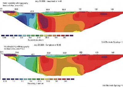
4. New geophysical techniques have been developed to monitor the movement of the saline interface in 2D beneath either the ocean beach or around tidal creeks. Much of this developmental work has been undertaken at Hat Head, close to Kempsey on the northern New South Wales Coast. Acworth & Dasey (2003) and Dasey (2010) give a detailed review of the development of these techniques. Acworth et al (2007) describe a new method for using radio-active tracers to detect the movement of groundwater adjacent to a tidal creek during a flood tide episode.
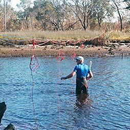
5. Understanding the movement of water in the coastal zone requires careful measurement of the density of the various columns of water as groundwater moves in response to the gradient in the water potential. This is frequently not the same as the simple hydraulic head measured with the assumption that the density of water is constant. It is now understood that there may be as many as 4 layers of different density water. At Hat Head adjacent to the tidal creek, fresh water overlies saline water that overlies freshwater that may also overlie deeper saline water. Soriano (2004) and Acworth (2007) report the use of a multi-channel manometer board to identify the actual head measurements required to determine groundwater movement. Dasey (in prep) reports on the use of electromagnetic conductivity logs to determine density differences required to determine groundwater movement.
6. Water fluxes through beach sands can have significant impacts on coastal erosion processes, currently under investigation by Dr Ian Turner's Coastal imaging @ UNSW team.