Posted 28 August 2020
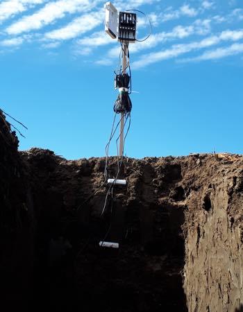
Results published from a Cotton RDC research project by UNSW has demonstrated how 2-dimensional time-lapse images can be used to map soil moisture status beneath an irrigated cotton growing field (Iverach et al 2017; Zare et al 2020).
Specifically, the research has shown that soil moisture can be mapped during the wetting- (i.e. irrigation) and monitored during the drying-phase, using commonly used electromagnetic induction data and inversion modelling software.
Future research is required to develop methods to map soil moisture status and wetting-up pathways in adjacent rows and across a whole field to enable 3-dimensional time-lapse imaging.
The time-lapse monitoring approach, has implications for soil and water use and irrigation management and will potentially allow farmers and consultants to identify inefficiencies in water application rates.
It can also be used as a research tool to potentially assist precision irrigation practices and to test the efficacy of different methods of irrigation in terms of water delivery in near real-time.
Further information about this research can be requested from Associate Professor John Triantafilis.

Professor Andy Baker features in American Water Resources Association ‘Water Resources Impact’, September 2020 edition.

The Connected Waters Initiative (CWI) is pleased to welcome Taylor Coyne to its network as a postgraduate researcher. If you’re engaged in research at a postgraduate level, and you’re interested in joining the CWI network, get in touch! The CWI network includes multidisciplinary researchers across the Schools of Engineering, Sciences, Humanities and Languages and Law.

The Grand Challenge on Rapid Urbanisation will establish Think Deep Australia, led by Dr Marilu Melo Zurita, to explore how we can use our urban underground spaces for community benefit.

On the 21 August 2020, CWI researchers made a submission to the National Water Reform Inquiry, identifying priority areas and making a number of recommendations as to how to achieve a sustainable groundwater future for Australia.

Results published from a research project between the Land Development Department (LDD) Thailand and UNSW has demonstrated how 2-dimensional mapping can be used to understand soil salinity adjacent to a earthen canal in north east Thailand (Khongnawang et al. 2020).

