Posted 20 January 2015
Central Australia has recently received record-breaking rains documented at the UNSW Fowlers Gap Arid Research Station
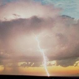
National Collaborative Research Infrastructure Strategy (NCRIS) -funded infrastructure at the UNSW Fowlers Gap research Station has recorded a rainfall event that greatly exceeded all previous records collected during 45 years of monitoring.
The event, measured in unprecedented detail by the network of remote sensors, records three fairly distinct bursts. The storm commenced at 16:30 on 9 January and lasted until 02:15 on the 11 January. The first event produced 24.4mm in 8 hours. This was followed after a break of approximately an hour, by 79.4mm of concerted rainfall over the next 14.75 hours. There was then another break of approximately 1 hour before the third more intense burst of 72.4mm in 8.25 hours.
"The 24 hours of rain that fell on 10 January was the largest daily event recorded for the station since measurements there began," said Professor Ian Acworth of the Connected Waters Research Intiative.
"176.2 millimetres of rain fell in 33.5 hours, which is an average of 5.26 millimetres per hour for almost a day and a half," he said.
The National Collaborative Research Infrastructure Strategy (NCRIS) funded the establishment of a network of 18 tipping bucket rain gauges that are all reporting over the internet so that remote events like this can be received and analysed in a timely manner. The NCRIS also funded the construction of 12 groundwater monitoring bores, a climate station, video monitoring and level gauges on creeks and dams on the Station.
The NCRIS contract was awarded to the UNSW Connected Waters Initiative (CWI) Research Centre and included work at 6 locations in eastern Australia that amounted to $15.8m. The work has recently been completed with the works at Fowlers Gap among the last to be carried out.
The National Collaborative Research Infrastructure Strategy (NCRIS) funded the establishment of a network of 18 tipping bucket rain gauges that are all reporting over the internet so that remote events like this can be received and analysed in a timely manner. The NCRIS also funded the construction of 12 groundwater monitoring bores, a climate station, video monitoring and level gauges on creeks and dams on the Station.
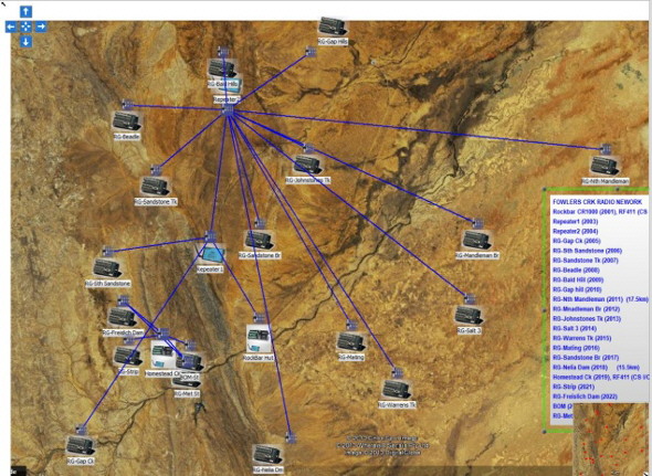
Rainfall station communications network established by Thiess Services.
Data from the measurement network is available remotely and is available for immediate use. Prior to its installation in 2013, station staff had to carry out a 125km run on farm bikes to download the rainfall measurements each time rain fell.
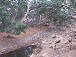
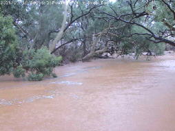
This nework documented detailed changes in water levels in the creek lake levels at the research station, showing how these responded to the changes in rainfall over time.
Video cameras recorded dramtic changes in water levels as the Fowlers Gap Creek flooded violently, resulting in cabling to the camera system there being ripped out.
Groundwater levels will continue to be monitored as the creek dries out to get a better idea of local groundwater recharge and use by the surrounding River Red Gums.
More information about the event and the measurements is available here.

Professor Andy Baker features in American Water Resources Association ‘Water Resources Impact’, September 2020 edition.

The Connected Waters Initiative (CWI) is pleased to welcome Taylor Coyne to its network as a postgraduate researcher. If you’re engaged in research at a postgraduate level, and you’re interested in joining the CWI network, get in touch! The CWI network includes multidisciplinary researchers across the Schools of Engineering, Sciences, Humanities and Languages and Law.

The Grand Challenge on Rapid Urbanisation will establish Think Deep Australia, led by Dr Marilu Melo Zurita, to explore how we can use our urban underground spaces for community benefit.

On the 21 August 2020, CWI researchers made a submission to the National Water Reform Inquiry, identifying priority areas and making a number of recommendations as to how to achieve a sustainable groundwater future for Australia.

Results published from a research project between the Land Development Department (LDD) Thailand and UNSW has demonstrated how 2-dimensional mapping can be used to understand soil salinity adjacent to a earthen canal in north east Thailand (Khongnawang et al. 2020).

