
Posted 20 April 2011
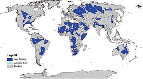
Diagram created by Jean Margat showing the world's 37 very large aquifer systems.
Mendel Khoo
Researcher, FDI Global Food and Water Crises Research Programme
Gary Kleyn
Manager, FDI Global Food and Water Crises Research Programme
Aquifers play a key role in the provision of water for farming and for consumption by animals and humans. Almost all parts of the global landmass hide a subterranean water body. Aquifers are underground beds or layers of permeable rock, sediment or soil where water is lodged and can be accessed to yield water. This paper explores some of the major aquifers around the world and determines how countries are coping with increased water usage.
Studying aquifers presents a number of problems, in part because scientists are yet to develop a complete picture of the globe's aquifer systems; the sub-surface geology still holds mysteries. Further discoveries of aquifers and information on their connectivity with surface water can be expected in the future. The process should be similar to the way in which new discoveries of energy sources beneath the earth's surface are still being made.
An additional impediment lies in the different terms used to describe aquifers, some of them arising simply because of language differences. Aquifers do not fit into one neat category, as there are many variations to their form. The terminology for aquifers can include: underground water basins; groundwater mounds; lakes and parts of rivers; as well as artesian basins, which are confined aquifers contained under positive pressure. Hence, aquifers are not only located underground but some, or all, parts may also be found on the surface.
Finally, much of the research into aquifers is focussed on identifying cross-boundary aquifers. The inventory of aquifers falls short, therefore, of providing a complete picture of their true number and extent. What does seem clear is that aquifers, in some shape or form and at varying depths, are found under most of the global landmass. Hence, we literally are walking on water.
Finding data from secondary sources on each particular aquifer is also problematic, when considering criteria such as: maximum capacity, current capacity, annual withdrawal rates and the number of people served by a particular aquifer. In many cases the data is not readily available.
One dictionary describes aquifers as water-saturated rock formations. The word aquifer means "water-bearing formation," i.e., Latin "aqua" (water) and "ferre" (to bear). One aquifer may refer to a single geologic formation, a group of formations or a part of a formation; in all cases, the formation must carry and yield a "significant" amount of water.
This paper explores some of the major aquifers around the world and determines how countries are coping with increased water usage. In no way is the list comprehensive as there are hundreds of aquifers, which cover much of the sub-surface. The paper will consider how many people have access to a particular aquifer, its average withdrawal levels and sustainability. Where no current statistics are available, statistics from The Footprint Network provide useful data that has been developed to show how much water each country used per annum between 1997 and 2001. The statistics collected have demonstrated a wide divergence in per capita water usage.
For example, South African per capita water use was 931 cubic metres of water per annum, whereas Australia used 1,393 m3, Greece, 2,389 m3 and the United States 2,483 m3. The world average is 1,243 m3 per year per person; creating a total annual demand of 7,452 cubic kilometres per annum (1).
Statistics from the United Nations indicate that the total volume of freshwater on the earth is around 35 million cubic kilometres; 30 per cent is stored underground and potentially available for human consumption.
Most of the water taken from aquifers is used for irrigation by the agricultural industry (70 per cent), with only eight per cent used for domestic consumption such as drinking. Water use, however, has been growing more than twice as fast as the world's population growth. The United Nations predicts that by 2025 two-thirds of the world's population could be living in countries with absolute water scarcity (2).
Hence, countries need to begin looking at possible solutions. Estimates indicate that by 2050 an additional 6,000 cubic kilometres of water will be required annually to feed an additional 2.5 billion people (3).
There are 37 great aquifer systems of the world (4). These 37 largest aquifers jointly cover almost 35 million square kilometres - equivalent to just under a quarter of the entire land surface.
1. Australia and New Zealand
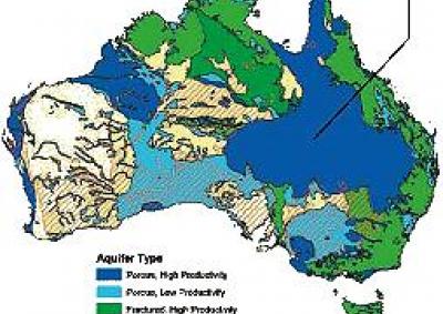
There are four main aquifers located in Australia, including one of the largest in the world known as the Great Artesian Basin. The Great Artesian Basin is located beneath the surface of four states (Queensland, Northern Territory, South Australia and New South Wales). It covers about one quarter of Australia and is estimated to contain 64,900 cubic kilometres of ground water (5). It is Australia's largest source of water and is sufficient to fill Sydney Harbour 130,000 times. It could supply the current Australian population for the next 2,500 years, even if replenishing rain stopped - based on Australia's current water use rate of about 26 cubic kilometres a year. Obviously, with greater water efficiency the water could supply the country for significantly longer.
The Gnangara Groundwater Mound and Jandakot Groundwater Mound are Western Australia's main water sources. Together they supply about 40 per cent of the State's drinking water. There is an estimated total of 150 cubic kilometres of water in various basins under Perth. The Gnangara Mound holds about 20 cubic kilometres of fresh water, while the Jandakot Mound holds close to four cubic kilometres. It is estimated that these water sources could keep Perth supplied for over a century (6). The Yarragadee Aquifer is also located in Western Australia and is situated beneath both the Gnangara and Jandakot Mounds. It is estimated to currently store 1,000 cubic kilometres of water, which is sufficient to supply Western Australia's current population for the next 370 years.
There are around 200 groundwater aquifers in New Zealand. Most of them, however, are shallow, making them vulnerable to pollutants from land use. One of the main aquifers is the Canterbury Plain Aquifer, located in the South Island of New Zealand.
Europe has an estimated 89 trans-boundary aquifers and many more that do not cross national boundaries.
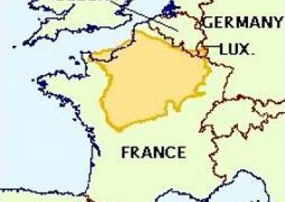
The largest aquifer in Western Europe is the Paris Aquifer which covers about half of France. In addition, Russia has three significant aquifers, known as the Russian Platform Basin, the North Caucasus Basin and the Pechora Basin.
1. Northern Africa
It has been said that the greatest untapped potential for water from underground aquifers lies in Africa. One of the main aquifers in Northern Africa is known as the Bas Saharan Basin. This transnational aquifer encompasses Tunisia, Algeria, Libya and Morocco and covers 140,000 square kilometres of land.
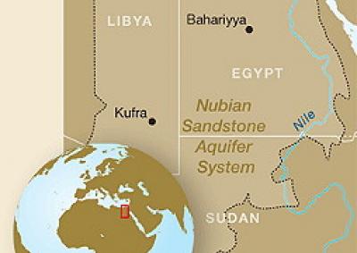
Another critical aquifer system in Northern Africa is the Nubian Sandstone Aquifer System. It covers parts of Sudan, Chad, Libya and most of Egypt. It is estimated to contain 150,000 cubic kilometres of high-quality water - sufficient to supply the four countries for the next 920 years, based on current annual water usage and without taking into account replenishing rains. There have been political disputes between the countries that use this System, with the latest being over Libya extracting substantial amounts of water to develop its own man-made river project. However, there are international development projects in place that have brought the four countries together to establish rational and equitable use of the System. Withdrawals from it have been increasing over the past 40 years; Libya and Egypt alone have extracted a total volume of 40 cubic kilometres from the Nubian Sandstone Aquifer System (7).
Other aquifers in Africa include: the Northern Sahara aquifer system of Algeria, Libya and Tunisia; the Basin of Murzuk-Djado of Libya, Algeria and Niger; the Basin of Taoudeni-Tanezrouft of Algeria, Mauritania, Mali, Burkina Faso and Guinea; the Senegal Mauritanian Basin of Mauritania, Senegal, Gambia and Guinea Bissau; the Iullemeden-Irhazer aquifer of Niger, Algeria, Mali and Nigeria; the Lake Chad Basin that covers parts of Niger, Nigeria, Chad, Cameroon and the Central African Republic; the Sudd-Basin Umm Ruwaba aquifer of Sudan and Ethiopia; the Ogaden-Juba Basin of Ethiopia, Somalia and Kenya, the Congo Basin of the Congo Democratic Republic and the Central African Republic; and the Cuvelai Basin-Upper Zambezi Basin of Angola, Botswana, Zambia and Zimbabwe.
1. Middle East
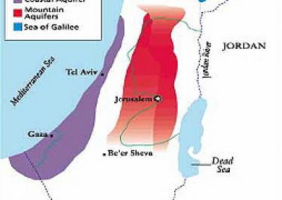
The Yarkon-Taninim Aquifer is shared between Israel and Palestine and is one of their biggest water sources. The Aquifer supplies Israel with about 0.34 cubic kilometres of water a year, while Palestine uses about 0.20 cubic metres a year (8). Other aquifers in this region include the Nablus-Gilboa Aquifer, which is mainly used by Israel for agricultural irrigation and supplies it with about 1.15 cubic kilometres a year. The third significant aquifer in the region is known as the Eastern Aquifer and supplies 0.40 cubic kilometres annually to Israel and 0.60 cubic kilometres to the Palestinians.
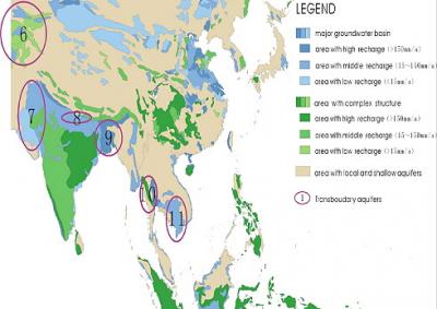
2. South Central Asia
Groundwater aquifers are an important source of water for India, providing 90 per cent of its drinking water and 80 per cent of its irrigation water needs (9). The amount of water in aquifers is estimated to be 430 cubic kilometres, or around one-quarter of India's water supplies. India is the largest user of groundwater in the world, with an estimated usage of 750 cubic kilometres annually (10). The Indo-Ganga-Brahmaputra basin has enormous fresh water resources that have not been utilised, according to a 2010 report by India's Central Ground Water Board Minister of Water Resources (11). The report suggests that tracts of north eastern India have 'quite productive' aquifers, while the Upper Gondwanas, 'constitute prolific aquifers'.
The Strategic Foresight Group believes that India could be facing a water deficit by 2030. Water availability is expected to decline to 1240 cubic metres per person per year, from the current level of 1730 cubic metres per person. The findings were published in the Group's paper, The Himalayan Challenge: Water Scarcity in Emerging Asia. Not taking into consideration the in-situ amount of water, the annual replenishable quantity of underground fresh water is 433 cubic kilometres. There are 12 major river basins, the largest being the Gangetic Plain Aquifer, which has an annual replenishable quantity of ground water of 206 cubic kilometres.
The Indian Ministry of Water Resources estimates that the in-storage underground water volume is 10,812 cubic kilometres, which it says can be retained for future use and harnessed in periods of crisis (12). The Indian Government is limiting the exploration of aquifers but believes that more needs to be done to develop and use the underground water resources.
With such large volumes of groundwater being consumed, India's ground water aquifers are under strain. The World Bank has reported that India's ground water table will begin to dry up in 15 years if corrective measures are not immediately put in place. In the same report, it stated that 60 per cent of India's aquifers will be in critical condition if current water usage trends continue (13). States in India that are experiencing serious water problems include: Rajasthan, Gujarat, Andhra Pradesh and Madhya Pradesh where water was in sufficient supply 15 years ago. The ground water levels have been depleted to below 300 metres and, with drought becoming a common problem, it is expected that these subterranean water levels will continue to fall. However, the deep water resources, in what is known as fossil aquifers, may still have untapped potential for the sub-continent.
3. Eastern Asia
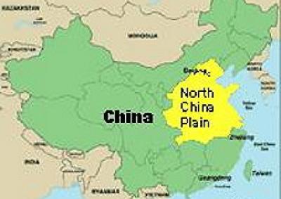
China is another country facing issues with its water supply from aquifers. China's available water supply from all sources (e.g. rivers and aquifers) has been falling over the years as water consumption has continued to increase. China's ground water usage volume has caused a depletion of an estimated 10 cubic kilometres per annum. This has resulted in large areas of land suffering serious land subsidence. Large aquifers in China include: the Alluvial Fan Aquifer of Juma River, Karsts Aquifer of Chezhoushan, Karst Aquifer of Easter Erdos Basin; and the Aquifer of the Yangtze River Delta (14).
The country draws 100 cubic kilometres a year, with 76 per cent of this taken from aquifers in the north. Estimates indicate that the amount of natural charge into underground aquifers is about 884 cubic kilometres per annum of which 656 cubic kilometres is in mountainous areas (15). There are, however, still 70 million people in China with no clean groundwater to drink. The problem for China is that the rain is not falling where it is needed. The demand is concentrated in certain areas but the recharge is across a wide geographical area that is not necessarily connected to the aquifers that are being used for extraction.
Another problem that China faces is ground subsidence over aquifers or "karst". More than 1,400 karst collapses have occurred, with the total number of collapse holes exceeding 40,000. Karst collapses occur in areas where limestone has been undermined by water erosion. In addition, seawater has intruded into coastal aquifers in the Liaoning, Hebei, Shandong, Guangxi and Hainan provinces.
Most of China's water is consumed by the agricultural industry. As a result of the decreasing water supply, China's agricultural industry has had to cut back production significantly. For example, China's overall grain production has fallen by 43 million tonnes from its peak of 392 million tonnes in 1998, to an estimated 358 million tonnes in 2005 (16). Still, the agricultural sector utilises an estimated 400 cubic kilometres of water annually (17). This cutback in grain production because of water scarcity, results in loss of revenue for the Chinese agricultural industry. With China's population estimated at 1.3 billion people, urban water consumption is estimated to have exceeded 80 cubic kilometres in 2010, a jump of 30 cubic kilometres a year from 2001 (18). China's response to the excessive use of water is to aim for a 60 per cent cutback in water used to produce each dollar of GDP by 2020 (19).
Other significant aquifers are: the Tarim Basin, located in the Taklimakan Desert in Central Asia; the North China Aquifer system; as well as the Huang-Huai-Hai and Song-Liao Plains in eastern China.
1. South America
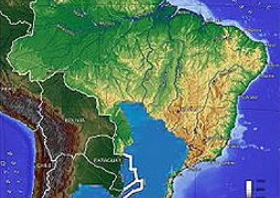
Deemed the largest aquifer in the world, the Guarani Aquifer covers 1,200,000 square kilometres and is located beneath Argentina, Brazil, Paraguay and Uruguay. It has a maximum capacity of 40,000 cubic kilometres of fresh water but is currently estimated to hold 37,000 cubic kilometres. The main use of the aquifer is for drinking purposes but it also has industrial and agricultural uses. It is estimated that 70 million people have access to the Guarani Aquifer while 24 million people have restricted access because they are located outside the boundaries of the aquifer (20).
2. Central America
Mexico has nine aquifers in the state of Mexico City alone. One of them is the Texcoco Aquifer, which is located in the Basin of the Valley of Mexico. This particular aquifer has experienced high levels of exploitation, with estimates reaching 850 per cent annually (21). This means water is being pumped out of the Texcoco Aquifer at a rate more than eight times the rate at which water is going in. The rest of the aquifers in Mexico are also over-exploited but none as severely as the Texcoco Aquifer (22). One of the consequences of the over-exploitation of aquifers in Mexico City has been the subsidence of the city by nearly 10 metres.
It is estimated that by 2025 Mexico will have a population of 19 million and this will create an estimated demand of 1.08 cubic kilometres of water; seventeen cubic metres more than in 2005 (23). Thus, Mexico faces a water crisis requiring it to pump out more water from its aquifers; already over-exploited to the extent that the country is sinking in efforts to meet future demand for water. Hence, Mexico needs to either look at other ways of sourcing water or look at ways of reducing population growth.
1. The United States
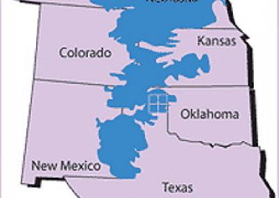
The Ogallala Aquifer is one of the largest aquifers in the world and is located across eight states in the United States: South Dakota, Nebraska, Wyoming, Colorado, Kansas, Oklahoma, New Mexico, and Texas. The Ogallala Aquifer system is estimated to provide 80 per cent of drinking water to people living within its boundaries. Like a lot of other aquifer systems throughout the world, the Ogallala Aquifer is experiencing excessive use. The quantity of groundwater held in 2005 was recorded at 3,600 cubic kilometres, but has declined by 300 cubic kilometres in five years. Julian Cribb in his book The Coming Famine, states that the aquifer could dry up within 25 years (24).
This paper seeks to give a brief insight into the current situation faced by a number of different countries using aquifers as a main source of water. For the majority of countries, water consumption from aquifers has been over-exploited; more is being pumped out than is being collected. This is an increasing problem because, as populations grow, there is a greater demand for water, which is becoming a declining commodity. The consequences of overexploiting aquifers, especially those which are located underground, are severe. Countries risk serious land subsidence, which can result in landslides and damage to infrastructure. Places like China and parts of India are already dealing with the consequences of over extracting water, with water tables falling in some areas and aquifers being depleted.
However, many countries are now becoming more aware of their high water consumption levels and the possible consequences if changes are not made. These countries have, or are at least talking about, setting policies in place to: limit or minimise water consumption; look to other forms of water; inherit or develop new technologies, perhaps from the oil and gas industry, to source water; and to limit irrigation usage by agriculture industries.
The consequences of the depletion of aquifers can be costly. For example:
Concern is often expressed about using water from aquifers at a rate that goes beyond the level of replenishment, because it is considered unsustainable. Yet aquifers in some parts of the world are large enough to sustain present consumption rates for centuries or, in some cases, thousands of years into the future. We could ask why we are not using this resource while still feeling comfortable about exploiting other resources that also have a finite life.
Intuitively it is easy to conclude that aquifers are reliant solely on rainfall for replenishment. Yet there is some evidence that water may have been sitting in situ since the creation of the earth and is part of the make-up of the earth. The late Lance Endersbee, who was an authority on global water, made a compelling case in his book A Voyage of Discovery that large quantities of water are deep in the ground and have been since the earth's creation. Water vapour coming from volcanoes also suggests the presence of water deep underground. Indeed, it has been argued that the Great Artesian Basin is feed from deep within the earth, in addition to intake from rainfall. Researchers cannot discount these possibilities. Our deepest mines go to depths of just a few kilometres and are only touching the surface of the earth, with its radius of 6,378 kilometres.
Fossil fuels are also not replenishable, yet they have provided the globe with incredible capacity and the means to lift living standards over the past century. Perhaps it is time for aquifers to be viewed in a similar way. Using the water in the aquifers could lift living standards in many parts of the globe. It could even lead the next economic expansion. If keeping the water beneath the surface is crucial to geological stability, as is likely to be the case in parts of the globe, this needs to be explained by hydrologists. If the fossil fuel extraction from below ground is anything to go by, water can also be taken and used judiciously, without permanent damage to the earth.
The challenge around the globe, but especially in countries that will have severe water shortages, will be to reduce water consumption and improve efficiency. Access to water, water rights, and trading in water will become increasingly important in the next century as demand for the resource increases. It is likely that inter- and intra-state conflict will occur over water. Therefore, water security will be a major issue facing governments around the world. The proper management of these aquifers could avert such conflicts. As water becomes more valuable we can expect an increase in underground exploration for new water sources. In the future we may see exploration companies listed on the stock exchange looking not for energy but water resources.
Any opinions or views expressed in this paper are those of the individual author, unless stated to be those of Future Directions International.
A Strategic Analysis Paper reproduced with permission from Future Directions International.
Groundwater level monitoring data recovered at the end of 2019 from Mystery Road at Breeza on the Liverpool Plains reveals a direct connection between the Gunnedah Formation unconsolidated sands and gravels and the underlying Permian coal measures. The connection is provided by the old deep channel of the Mooki River that cuts down into the coal measures. This is a crucial piece of evidence to be incorporated into groundwater models.

What are the effects of fire on water underground? Let’s think about what happens on the surface, and translate that to what is likely to happen to the subsurface.

The effects of tidal forces on groundwater might be less apparent to us than their effects on the ocean, but they’re just as important.

Dr Oliver Knox has brought together information from some of the industry’s researchers conducting work oncotton-producing soils.

Groundwater research at ANSTO has provided crucial information to support the management of finite groundwater resources appropriately and sustainably—answering questions about groundwater recharge, groundwater age and dynamics, the interaction between surface water and groundwater and salinisation.

Professor Andy Baker features in American Water Resources Association ‘Water Resources Impact’, September 2020 edition.
CWI’s network of researchers is widening - Welcome Taylor Coyne!


