Posted 5 September 2008
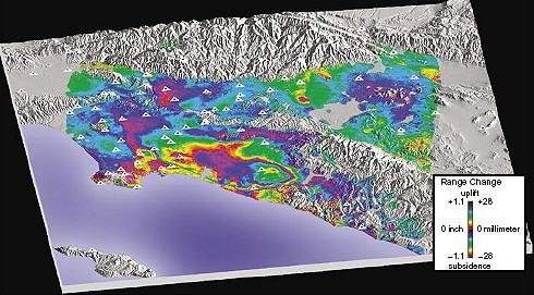
Interferogram showing deformation in the Los Angeles Basin, April 1998 - May 1999 (USGS, 2005)
Subsidence is lowering of the ground surface that results from compaction or consolidation of the geological materials beneath, such as soil and rock.
Consolidation of these geological materials occurs when stress is applied that causes them to decrease in volume. Subsidence resulting from consolidation can be caused by a variety of factors that vary from place to place.
Subsidence is a natural process in certain landscapes where there are porous sediments and rocks, or where they are highly soluble. Subsidence can affect clay, peat, some silts and some sands, limestones with large underground voids and can be associated with mining activity and old mine workings.
Groundwater extraction can also lead to consolidation and subsidence by causing a decrease in the volume - and loss of pressure - of pore-water in the substrate.
The downward movement of subsidence is measured relative to a reference level (datum). Movement of the ground surface in the opposite direction to subsidence is called uplift.
Why does subsidence occur when groundwater is extracted?
Subsidence in groundwater basins mainly occurs in layers of clay, silt and peat, rather than within aquifer materials that conduct the groundwater like sand and gravel.
This is because sediments such as clay are very porous and are readily deformed, imparting a high potential for consolidation. The amount of subsidence in clay depends on the initial water content of the clay and how much stress is applied.
Groundwater pumping that exceeds the natural rate of recharge in the basin can lower groundwater levels. This water loss decreases the pore water pressure contributing to the support of overlying sediment, causing an overall decrease in the volume of the sediment matrix. As the sediment is compacted by gravity, the ground surface above becomes lower. This is a common cause of subsidence in groundwater basins.
How is subsidence measured?
A variety of methods can be used to detect and measure subsidence. These include surveying with real time global positioning systems (RTK GPS), installation of extensiometers in boreholes and advanced satellite mapping techniques.
One advanced satellite mapping technique, called Satellite Interferometric Synthetic Aperture Radar (InSAR), is often used for regional-scale subsidence measurement.
InSAR can detect how much the ground surface has subsided (or uplifted) by measuring the distance between it and a spacecraft. This is accomplished by measuring the differences between radar signals transmitted to the ground surface from the same point in space at different times, usually months or years apart. The radar data is combined into an interferogram image, which shows the magnitude of the differences between the successive signals, detecting movement as little as 5-10mm.
The technology behind InSAR was first used to remotely explore the surfaces of the Moon and Venus. Since then the method has been refined and is now used for many applications on earth, such as earthquake and volcano monitoring. InSAR is less expensive than other methods, providing millions of data points over large areas as much as 10,000 square kilometres.
Methods of measuring land subsidence
| Measure- ment | Resolution1 (mm) | Samples/ survey2 | Spatial scale | |
| Spirit level | Vertical | 0.1-1 | 10-100 | Line-network |
| Geodimeter | Horizontal | 1 | 10-100 | Line-network |
| Borehole extensiometer | Vertical | 0.01-0.1 | 1-3 | Point |
| Tape extensiometer | Horizontal | 0.3 | 1-10 | Line-array |
| Invar wire extensiometer | Horizontal | 0.0001 | 1 | Line |
| Quartz tube extensiometer | Horizontal | 0.00001 | 1 | Line |
| GPS | Vertical & horizontal | 20 (vertical) 5 (horizontal) | 10-100 | Network |
| InSAR | Range | 5-10 | 100,000- 10,000,000 | Map pixel3 |
Where has subsidence been detected?
Cases of subsidence associated with groundwater extraction have been identified in various places around the world.
In Mexico City subsidence of 9 m has been caused by over-pumping of groundwater from sand layers interbedded with clay.
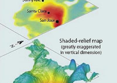
The Santa Clara Valley in California has been subsiding substantially in association with groundwater pumping since 1940. An 8-month interferogram (right) reveals seasonal subsidence of about 30 mm near San Jose during 2005. This subsidence has resulted from an overall reduction of 10 m in groundwater levels due to extraction.
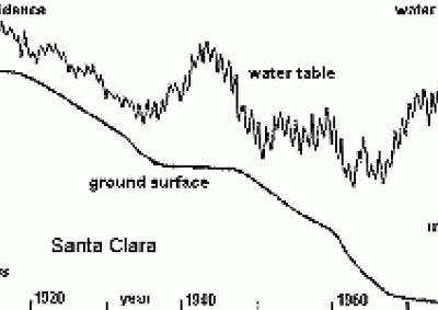
The strong relationship between groundwater level and subsidence in this area is illustrated in the graph below where changes in the rate of subsidence correlate with lowering groundwater levels. Between 1910 and 1980, the Santa Clara Valley ground surface has subsided by 4m.
In Australia, subsidence has been recognised in the Latrobe Aquifer in the Gippsland Basin of Victoria and in the Lower Namoi Valley of New South Wales. Possible subsidence has also been reported at a groundwater extraction site in the Lower Murrumbidgee area of New South Wales.
In Gippsland, subsidence of about 2 m has been recorded over an area of several square kilometers near Morwell in the Latrobe Valley. Coastal areas are of greatest concern, where authorities are now acting to deal with the increased threat of inundation of subsiding land by the sea.
Over the last 40 years, pumping groundwater for irrigation, removal of groundwater for open-cut coal mining operations (dewatering) and substantial groundwater extractions related to ongoing offshore oil and gas production in Bass Strait have lowered groundwater levels in the Latrobe Aquifer at a rate of approximately 1 m per year.
This is because the rate of natural aquifer recharge is not sufficient to compensate for the rate of extraction by industry, resulting in permanent change to the Gippsland landscape.
Cases of subsidence around the world (Nelson, 2007)
| Maximum subsidence (m) | Area affected (km2) | Cause | |
| Long Beach, Los Angeles, USA | 9.00 | 50 | Petroleum withdrawal |
| San Joaquin Valley, USA | 8.80 | 13,500 | Groundwater withdrawal |
| Mexico City, Mexico | 8.50 | 225 | Filled lake |
| Tokyo, Japan | 4.50 | 3,000 | Groundwater withdrawal1 |
| Houston, USA | 2.70 | 12,100 | Groundwater withdrawal (possibly oil & gas extraction)1 |
| Shanghai, China | 2.63 | 121 | Groundwater withdrawal1 |
| New Orleans, USA | 2.00 | 175 | Groundwater withdrawal, construction dewatering and drainage2 |
| Bangkok, Thailand | 1.00 | 800 | Groundwater withdrawal2 |
| Venice, Italy | 0.22 | 150 | Groundwater withdrawal1 |
| London, England | 0.30 | 295 | Groundwater withdrawal, construction dewatering and drainage2 |
| Latrobe Valley, Victoria, Australia | 2.00 | Several km2 | Groundwater withdrawal from mining and irrigation |
| Namoi Valley, NSW, Australia | 0.5 | Not available | Groundwater withdrawal |
Why does subsidence matter?
Subsidence is of great importance because it is irreversible once it has occurred.
The majority of cases of subsidence recognised so far have been found to have developed due to increased extraction of groundwater, oil and gas.
Subsidence can cause many additional problems including:
Can subsidence be predicted?
Subsidence can be predicted by developing a detailed understanding of the geotechnical response of the earth to the changes in stress caused by reduced groundwater levels.
Predicting subsidence where groundwater extraction occurs involves establishing the thickness and distribution of compressible sediments, understanding how these sediments behave in response to changing stresses, and accurately estimating the level of groundwater expected to remain in an aquifer after extraction has taken place.
Accurately estimating future groundwater levels can pose the greatest challenge to successful prediction of subsidence because groundwater requirements for agriculture and industry are inherently dynamic - and also uncertain - due to the various climatic, socio-economic and policy factors involved.
Links and references:
Groundwater level monitoring data recovered at the end of 2019 from Mystery Road at Breeza on the Liverpool Plains reveals a direct connection between the Gunnedah Formation unconsolidated sands and gravels and the underlying Permian coal measures. The connection is provided by the old deep channel of the Mooki River that cuts down into the coal measures. This is a crucial piece of evidence to be incorporated into groundwater models.

What are the effects of fire on water underground? Let’s think about what happens on the surface, and translate that to what is likely to happen to the subsurface.

The effects of tidal forces on groundwater might be less apparent to us than their effects on the ocean, but they’re just as important.

Dr Oliver Knox has brought together information from some of the industry’s researchers conducting work oncotton-producing soils.

Groundwater research at ANSTO has provided crucial information to support the management of finite groundwater resources appropriately and sustainably—answering questions about groundwater recharge, groundwater age and dynamics, the interaction between surface water and groundwater and salinisation.

Professor Andy Baker features in American Water Resources Association ‘Water Resources Impact’, September 2020 edition.
CWI’s network of researchers is widening - Welcome Taylor Coyne!