
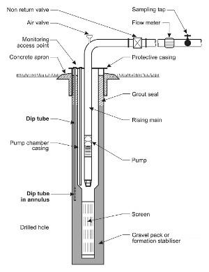
Figure 1: Monitoring dip tubes in an irrigation bore.
Why monitor groundwater?
If you aren't watching your groundwater source, it is like running a car without checking the oil. Keeping track of groundwater levels and quality is a very important part of ensuring resource availability and, sustainable management. It is the responsibility of users to test and treat bore water to ensure the quality is fit for the intended usage.
What to monitor
Monitoring can involve groundwater level monitoring and/or quality monitoring. Groundwater level should be measured from a standard reference point such as ground level or the top of casing.
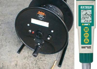
Water salinity can be monitored simply by an EC meter (electrical conductivity). Water salinity should also be periodically analysed by a laboratory to measure concentration of major cations and anions including sodium, calcium, magnesium, chloride, sulphate and bicarbonate salts. Full laboratory analysis can be used to check more frequent EC measurements.
Other basic water quality tests are nitrate and Escherichia coli (E. coli), an indicator of bacterial contamination. Note there are hundreds of water quality parameters that can be tested depending on the intended use of water. This fact sheet concentrates on monitoring for irrigation and possible salinity impacts; other water quality tests should be undertaken based on advice from hydrogeological specialists.
What equipment is needed?
Sampling methods in the Australian Standards* or more specific regulatory guideline should be followed by personnel who are trained in groundwater quality sampling:
How often to monitor?
Groundwater level - weekly during groundwater pumping season, monthly at other times. A consistent record over many years is most important.
Water salinity (EC) - monthly during groundwater pumping
Water salinity (major salt ions) - once per year, preferably during the non pumping season.
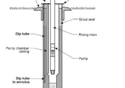
What is a piezometer?
A piezometer is a specially designed bore with a short intake screen to monitoring groundwater levels at a specific point in an aquifer. Ideally, monitoring should be undertaken in both irrigation bores and piezometers.
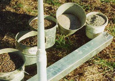
Figures 2 and 3 show how to construct a shallow monitoring piezometer and the materials that are required.
Shallow piezometers can be installed in an auger hole to about 5m depth. Deep piezometers require a drilling rig and specialised materials to prevent leakage between different aquifer systems.
How much does monitoring cost?
Your time is the most significant cost. Keep in mind A consulting hydrogeologist or laboratory that is NATA certified for the tests that are required should be contacted for current prices. A rough guide for EC and major salt ions is about $50 per sample, and about $20 per sample for nutrients. Labs can also advise about suitable methods*, sample handling procedures, and can provide bottles to use to ensure that the data is reliable. A consulting hydrogeologist will provide a full assessment service that will provide interpretation of laboratory results.
* Standards Australia & Standards New Zealand (1998) 'Water Quality - Sampling Part 11: Guidance on Sampling of Groundwaters' Australian/New Zealand Standard AS/NZS 5667.11:1998
Sources:
Modified after Timms, 1997.

Facts curated by Dr Landon Halloran, Dr Gabriel Rau and Dr Martin Andersen from UNSW Sydney. Graphics and design by Anna Blacka from UNSW Sydney. Funded by the NSW Research Acceleration and Attraction Program to support the Australian Government National Collaborative Research Infrastructure Scheme.

This resource introduces aquitards and aquicludes, and discusses some of the cutting-edge approaches used to understand the movement of water and contaminants through the ground.

Having a geologically realistic conceptual site model is important for characterising hydraulic connectivity throughout aquifer systems, and modelling water transit times.

The use of heat as a tracer promises to be an excellent alternative to traditional assessment methods for quantifying exchange between surface water and ground water.

There are two common mistakes often made when calculating how much groundwater storage levels have changed.


