
Posted 6 October 2015

Wrapping up hundreds of meters of rock core from the ground to preserve the water inside the pores.
By Katarina David, Andy Baker and Wendy Timms
Groundwater is an essential resource that provides drinking water to billions of people around the world. Here in Australia – the driest inhabited continent in the world – water is a particularly precious resource that we need to manage carefully.
Yet mining and other subsurface engineering projects have the potential to impact groundwater. In the Sydney Basin region, underground coal mines operate near surface water reservoirs that are important for Sydney’s water supply. In other regions, coal seam gas extraction is being managed to minimise risk to adjacent aquifers.
Some mines also operate deep below wetlands and sensitive ecosystems. In other areas, copper, gold and coal mines are going deeper underground, and we have limited knowledge of how they will interact with groundwater.
So it is essential that we improve our knowledge of how ground water connects with surface water and aquifers, which is precisely what we’re doing at the Connected Waters Initiative Research Centre (CWI) at UNSW.
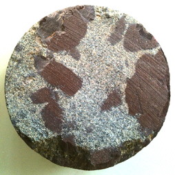 Water is extracted from rock samples such as this one.
The best tracer of groundwater is the water itself. In our recent study, we measured the different isotopes within water found in the rock. This can tell us about surface water-groundwater interactions in the past, and provides an essential baseline for any future changes.
To gather the samples, we had to drill 300 metres through layers of sandstone, siltstone and claystone to extract a core. This core then had to be carefully packed and sealed to preserve the moisture held in the rock.
Back in the laboratory, we had to carefully prepare bags with moist rock samples and dry air. We then used a specialised laser technology, called Off-Axis Integrated Cavity Output Spectroscopy (OA-ICOS) to “sniff” the air in the bag to determine its composition. It uses a system of mirrors to measure the amount of laser energy absorbed by water molecules of different mass, and can pick out different water isotopes.
We used this new technology to measure for the first time the water in rock pores of the strata in the Sydney Basin. We compared its isotope composition to known natural tracer composition in rainfall, surface water and other known water sources.
This allowed us to work out where the water came from. We also identified four distinctive layers of rock, or hydrogeological zones, which control groundwater movement in the Sydney Basin.
Before we conducted our research, we simply didn’t know much about the deep groundwater system in Sydney Basin. With our new record, this means that if some future mining project impacts the groundwater, we can now use this pore water isotope records as a novel baseline to help determine the extent of the impact.
Water moves very slowly underground at our site, and has taken a long time to reach a depth of 300 metres. The source of the groundwater is the rain, either directly entering the ground from rain events, or indirectly through water leaking from rivers, lakes and swamps.
We found the isotopic composition of the deep water was similar to that of modern rainfall, which means the groundwater system in the Sydney Basin has been replenished under similar conditions to today for thousands of years. This provides us with baseline conditions for water in the Sydney Basin.
Without the new water tracing technology, it would not have been possible to identify the hydrogeological zones and assess their characteristics.
This new technology also has the advantage that hundreds of rock samples from a single core can be analysed quickly and cheaply, as an alternative to installing many boreholes at different depths. The new approach can also be used for sites where the groundwater is very deep or held tightly in the pores of the rock.
It can also be used where the movement of the ground can damage water monitoring bores. This technology can help trace where surface water flows underground, and where the connection exists between the surface water and groundwater which support creeks and wetland ecosystems.
Our research provides a method for measuring a baseline against which we can assess any future impacts on groundwater from mining operations, groundwater abstraction or climate change. The technique can be used anywhere in the world to provide similar data.
Given the immense importance of groundwater both locally and regionally, it is important that more research is undertaken in order to provide better understanding of this precious resource.
This article was originally published on The Conversation. Read the original article.
Groundwater level monitoring data recovered at the end of 2019 from Mystery Road at Breeza on the Liverpool Plains reveals a direct connection between the Gunnedah Formation unconsolidated sands and gravels and the underlying Permian coal measures. The connection is provided by the old deep channel of the Mooki River that cuts down into the coal measures. This is a crucial piece of evidence to be incorporated into groundwater models.

What are the effects of fire on water underground? Let’s think about what happens on the surface, and translate that to what is likely to happen to the subsurface.

The effects of tidal forces on groundwater might be less apparent to us than their effects on the ocean, but they’re just as important.

Dr Oliver Knox has brought together information from some of the industry’s researchers conducting work oncotton-producing soils.

Groundwater research at ANSTO has provided crucial information to support the management of finite groundwater resources appropriately and sustainably—answering questions about groundwater recharge, groundwater age and dynamics, the interaction between surface water and groundwater and salinisation.

Professor Andy Baker features in American Water Resources Association ‘Water Resources Impact’, September 2020 edition.
CWI’s network of researchers is widening - Welcome Taylor Coyne!

