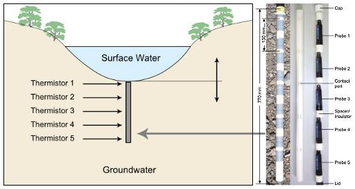
Diagram of a temperature array and installation in a streambed.
Introduction
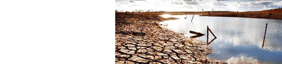
Groundwater and surface waters are connected and form one single resource (Winter et al., 1998). Interactions between surface water and groundwater bodies occur at the boundaries e.g. lakes, streams, storage dams and irrigation channels. In a natural system, water can either discharge from streams through the hyporheic zone or enter the subsurface thereby recharging the underlying aquifer, or discharge from the ground to maintain water flow in streams (base flow).
Quantifying water exchange at the boundary continues to impose a challenge on water management because of the dynamic flow conditions and limitations inherent to traditional investigation methods. Sustainable water management requires detailed knowledge of exchange flow direction and magnitude.
The use of heat as a tracer promises to be an excellent alternative to traditional exchange assessment methods. It is based on the quantification of heat flow by measuring sediment temperatures. Because heat flow in shallow hydrogeological systems is highly influenced by the flux of water, the flow rate can be calculated applying appropriate heat models. Although methods have been developed, there is no thorough testing of model validity and applicability to different field conditions.
Field tool
In order to measure sediment temperatures in the streambed, a multi-level streambed probe was designed. It consisted of a PVC pipe with five screened contact ports in depths of 0, 0.15, 0.3, 0.45 and 0.6 m within the streambed. The pipe hosts self-contained and automated devices (HOBO U22 Pro v2) continuously measuring the sediment temperature at each port with a sampling interval of 15 min. The logger array is lowered vertically into the sediment with the uppermost logger measuring the temperature at the bottom of the surface water column. The tool can be deployed at the bottom of any surface water body for any period of time (Rau et al., 2010). However, it should continuously record temperatures for at least one month.
Methodology
After successful deployment the probe offers sediment temperature depth time series that can be processed with heat transport models. Daily changes in surface temperature propagate into water bodies and penetrate the streambed. This natural diel sediment temperature signal features amplitude damping and phase shift with significant dependency on magnitude of vertical water flow. Hence these two attributes can be utilised for mathematical modelling of heat transfer with focus on solving for flow velocity using the conductive convective heat transport differential equation (HTE).
An analytical solution to the equation offers the capability to predict sediment temperatures at any deeper point (Forward Modelling) using thermal records as data input (Silliman et al., 1995). Through fitting of observed with computed temperature time series a time average of the vertical flow magnitude can be estimated. The HTE was also solved with sinusoidal upper and constant lower temperature boundary conditions (Stallman, 1965). The solution can be rewritten to obtain amplitude ratio and phase shift formulations that can iteratively be solved for flow velocity with temperature records recorded at two different depths (Hatch et al., 2007). The recorded temperatures must be filtered to cancel any noise and retain the diel temperature signature. This method offers a temporal resolution of two daily streambed flow values. For results refer to Rau et al. (2010).
Application potential
Research into the use of natural heat as tracer offers the capability for deployment in many different situations. Application of the method comprises the potential to:
Links and further information
Researchers
Gabriel C. Rau, Martin S. Andersen, R. Ian Acworth
University of New South Wales - Connected Waters Initiative
Funding
This research project is funded by the National Water Commission and the National Program for Sustainable Irrigation (Grant Number UNS5127).
References
Hatch, C. E.; Fisher, A. T.; Revenaugh, J. S.; Constantz, J. & Ruehl, C. (2006), 'Quantifying surface water-groundwater interactions using time series analysis of streambed thermal records: Method development', Water Resources Research 42(10).
Rau, G. C., Andersen, M. S., McCallum, A. M., and Acworth, I. R. (2010), 'Analytical methods that use natural heat as a tracer to quantify surface water-groundwater exchange, evaluated using field temperature records', Hydrogeology Journal 18, 1093-1110, doi:10.1007/s10040-010-0586-0
Silliman, S. E.; Ramirez, J. & McCabe, R. L. (1995), 'Quantifying Downflow through Creek Sediments Using Temperature Time-Series - One-Dimensional Solution Incorporating Measured Surface-Temperature', Journal of Hydrology 167(1-4), 99-119.
Stallman, R. W. (1965), 'Steady 1-Dimensional Fluid Flow in a Semi-Infinite Porous Medium with Sinusoidal Surface Temperature', Journal of Geophysical Research 70(12), 2821-.
Winter, T. C.; Harvey, J. W.; Franke, O. L. & Alley, W. M. (1998), 'Ground Water and Surface Water - A single Resource', Technical report, US Geological Survey, Denver, Colorado.

Facts curated by Dr Landon Halloran, Dr Gabriel Rau and Dr Martin Andersen from UNSW Sydney. Graphics and design by Anna Blacka from UNSW Sydney. Funded by the NSW Research Acceleration and Attraction Program to support the Australian Government National Collaborative Research Infrastructure Scheme.

This resource introduces aquitards and aquicludes, and discusses some of the cutting-edge approaches used to understand the movement of water and contaminants through the ground.

Having a geologically realistic conceptual site model is important for characterising hydraulic connectivity throughout aquifer systems, and modelling water transit times.

The use of heat as a tracer promises to be an excellent alternative to traditional assessment methods for quantifying exchange between surface water and ground water.

There are two common mistakes often made when calculating how much groundwater storage levels have changed.