Posted 7 January 2010
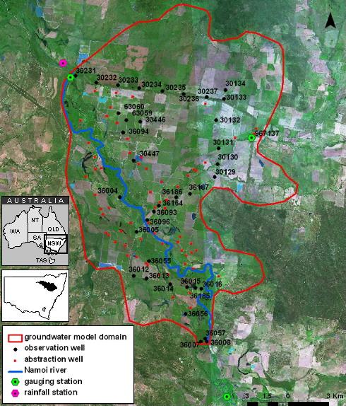
Study area with the location of observation wells, abstraction wells, gauging and rainfall stations in the groundwater model domain.
New groundwater flow modelling developed by the UNSW Connected Waters Initiative team aims to help provide a better understanding of the dynamics of the alluvial aquifer in the Maules Creek Catchment using an integrated approach to modelling catchment water resources.
The project, led by Ian Acworth and including Beatrice Giambastiani and Andrew McCallum, forms part of investigations of groundwater and surface water resources conducted for the Cotton Catchment Communities CRC.
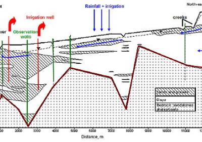
Situated in northern New South Wales, the Namoi River flows through the catchment and is gauged at two locations: Boggabri (in the South) and Turrawan (in the North). Since the mid 1980s, flood irrigation farming along the Namoi River has relied on groundwater abstraction (68 irrigation wells) to grow cotton, sorghum and wheat.
Throughout the catchment there are 37 groundwater monitoring boreholes (64 observation points) installed by the NSW state government with the standing water level being recorded 3 to 4 times each year.
The model was generated using the FEFLOW 5.4 finite element flow and transport code, utilising measurements of physical processes in this complex aquifer system, including:
The hydrogeology depicted in the model involves 9 layers bounded by impermeable bedrock. Hydrologic stresses include diffuse recharge (computed using daily soil moisture balances based on rainfall and evapotranspiration records, soil type and land use), irrigation return (deep drainage), stream-aquifer interaction, lateral groundwater inflow/outflow and groundwater pumping.
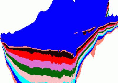
The hydraulic head distribution for 1978, obtained from a steady state model, was used as the initial condition for the transient model which was run from January 1978 to April 2007. The hydraulic conductivity distribution in the model was assigned on the basis of a 3D geologic model built in EarthVision and Mathematica using bore logs from the DWE database.
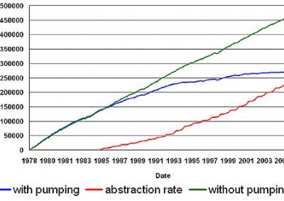
In order to assess the effect of groundwater abstraction on the stream-aquifer interaction, a scenario in which groundwater abstraction (pumping) occured was compared to a scenario without groundwater abstraction. The total river flux versus time was computed for each scenario.
In the scenario without groundwater abstraction, the river gained water from the aquifer, with variations through time due to climatic effects.
In the groundwater pumping scenario, the river changed from gaining to losing during the irrigation season. Overall, less groundwater discharged into the Namoi River during the pumping scenario (the cumulative flux from the aquifer to the river is diminished by 20% over the whole period post 1985) as seen in the cumulative flow curves.
The model performance was generally good. The model succesfully simulated the recovery of water levels after the irrigation season and was able to reproduce water level changes that had previously been observed over the long term. However, in areas where the groundwater abstraction-induced drawdown was large (up to 8-10 m) the effect of this seasonal dynamic was reduced.
So far, this project has improved understanding of the alluvial aquifer system and its dynamics. The interim findings of this modelling study were recently presented to landholders in the Maules Creek area. Advanced modelling of groundwater changes over time are currently in progress.
Groundwater level monitoring data recovered at the end of 2019 from Mystery Road at Breeza on the Liverpool Plains reveals a direct connection between the Gunnedah Formation unconsolidated sands and gravels and the underlying Permian coal measures. The connection is provided by the old deep channel of the Mooki River that cuts down into the coal measures. This is a crucial piece of evidence to be incorporated into groundwater models.

What are the effects of fire on water underground? Let’s think about what happens on the surface, and translate that to what is likely to happen to the subsurface.

The effects of tidal forces on groundwater might be less apparent to us than their effects on the ocean, but they’re just as important.

Dr Oliver Knox has brought together information from some of the industry’s researchers conducting work oncotton-producing soils.

Groundwater research at ANSTO has provided crucial information to support the management of finite groundwater resources appropriately and sustainably—answering questions about groundwater recharge, groundwater age and dynamics, the interaction between surface water and groundwater and salinisation.

Professor Andy Baker features in American Water Resources Association ‘Water Resources Impact’, September 2020 edition.
CWI’s network of researchers is widening - Welcome Taylor Coyne!