Posted 22 August 2012
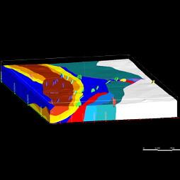
A Leapfrog 3D model of the regional geology surrounding Wellington Caves, NSW, Australia (Honours student Aaron Fordham)
The University of New South Wales is providing its first 3D Geological Modelling course (groundwater, mining, oil and gas) using Leapfrog software.
The course will run for one semester for students majoring in environmental science, geology, hydrogeology, mining and petroleum engineering.
Need for industry-relevant skills
Course coordinator Associate Professor Bryce Kelly wasn't surprised when the course was fully subscribed from the outset as students are becoming increasingly aware of the need to have skills relevant to the industry.
"Earth scientists will always be confronted with making decisions based on limited data sets. Therefore, it is important to understand how to maximise geological interpretations from sparse data sets, while understanding the limitations of what can be inferred," he said.
User friendly and easy to learn
"It's essential for our students to be skilled at using the latest software. We've been very pleased with Leapfrog because it's user friendly. Students can build complex geological models with just a couple of hours of training. Leapfrog is especially good for modelling intrusions and manipulating surfaces," said Associate Professor Kelly.
The course will explore how to combine various 3D spatial data sets to solve problems in 3D geological settings. It further covers how to construct 3D geological conceptual site models for quantification and communication.
This initiative is the first for Leapfrog and they are optimistic other universities will soon offer similar courses.
"Leapfrog is committed to working closer with the academic world. It's a key facet of our long term strategy to support the geologists of tomorrow," said Richard Lane, Product and Research Manager at Leapfrog.
Topics covered by the course include introduction to scripting, gridding algorithms, constructing 3D geological computer models of aquifers, mineral deposits and reservoirs, gridding of faulted and folded geological data, geostatistical simulation, facies modelling, and calculating the volume of a resource (water, ore, oil and gas).
Case studies from regional hydrogeology, contaminated sites, mining, and petroleum will be presented.
Links:

Professor Andy Baker features in American Water Resources Association ‘Water Resources Impact’, September 2020 edition.

The Connected Waters Initiative (CWI) is pleased to welcome Taylor Coyne to its network as a postgraduate researcher. If you’re engaged in research at a postgraduate level, and you’re interested in joining the CWI network, get in touch! The CWI network includes multidisciplinary researchers across the Schools of Engineering, Sciences, Humanities and Languages and Law.

The Grand Challenge on Rapid Urbanisation will establish Think Deep Australia, led by Dr Marilu Melo Zurita, to explore how we can use our urban underground spaces for community benefit.

On the 21 August 2020, CWI researchers made a submission to the National Water Reform Inquiry, identifying priority areas and making a number of recommendations as to how to achieve a sustainable groundwater future for Australia.

Results published from a research project between the Land Development Department (LDD) Thailand and UNSW has demonstrated how 2-dimensional mapping can be used to understand soil salinity adjacent to a earthen canal in north east Thailand (Khongnawang et al. 2020).

