Posted 20 January 2015
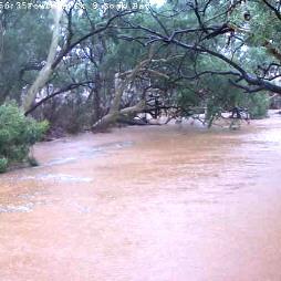
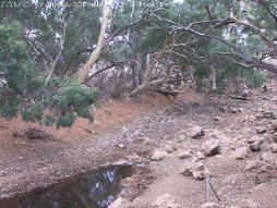
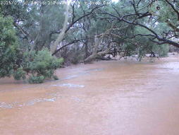
Flooding at Fowlers Gap Creek.
In January 2015, infrastructure at the UNSW Fowlers Gap research Station recorded a rainfall event that greatly exceeded all previous records collected during 45 years of monitoring.
The National Collaborative Research Infrastructure Strategy (NCRIS) funded network of remote measurement devices and cameras has provided documentation of this event in unprecedented detail.
The rainfall event came in three fairly distinct bursts at the UNSW Fowlers Gap Arid Research Station. The storm commenced at 16:30 on 9 January and lasted until 02:15 on the 11 January.
The first event produced 24.4mm in 8 hours. This was followed after a break of approximately an hour, by 79.4mm of concerted rainfall over the next 14.75 hours. There was then another break of approximately 1 hour before the third more intense burst of 72.4mm in 8.25 hours.
176.2mm of rain fell in 33.5 hours. That is an average of 5.26mm/hr for almost a day and a half, which is far in excess of previous records in the 45 years of monitoring at Fowlers Gap!
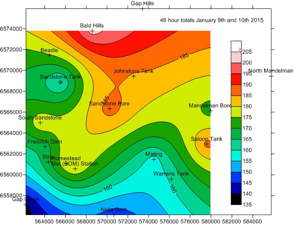
The distribution of rainfall over the station for the 48 hours recorded during 9 and 10 January. Gauges at Gap Hills and North Mandelman were found to have become blocked on examination of the data and have been left out of the plot.
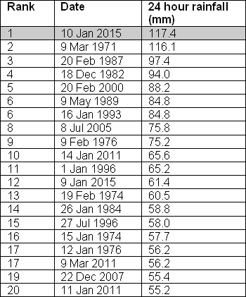
The previous highest rainfall over a 48 hour period was 117.4mm that fell on 9 March 1971. Note that the arbitrary rain day commences at 09:00. Where events span the end of one day and the beginning of the next, confusion can occur about the totals that actually fall in an event.
Comparison with previous 24 hour rain events confirms that the 24 hours of rain that fell on 10 January was the largest (just!) daily event recorded for the station over a 45 year period.
The National Collaborative Research Infrastructure Strategy (NCRIS) funded the establishment of a network of 18 tipping bucket rain gauges that are all reporting over the internet so that remote events like this can be received and analysed in a timely manner. The NCRIS also funded the construction of 12 groundwater monitoring bores, a climate station, video monitoring and level gauges on creeks and dams on the Station.
The NCRIS contract was awarded to the UNSW Australia Connected Waters Initiative (CWI) Research Centre and included work at 6 locations in eastern Australia that amounted to $15.8m. The work has recently been completed with the works at Fowlers Gap among the last to be carried out.
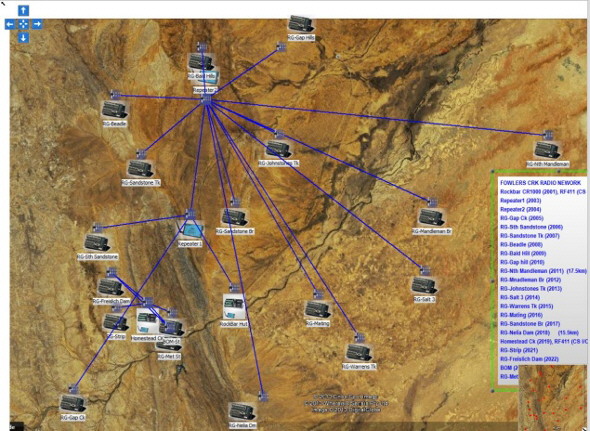
Rainfall station communications network established by Thiess Services.
The work at Fowlers Gap was subcontracted to Thiess Services based in Mildura and overseen by the Water Research Laboratory at Manly Vale. Monitoring results are available on the web and updated daily via the CWI NCRIS web site.
Rainfall has been monitored at the Research Station for the past 45 years. Totalising rain gauges were established in each of the paddocks at the 400km2 station so that grass growth could be predicted and an estimate of sustainable sheep numbers established.
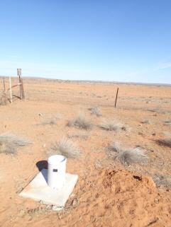
Until 2013, each time rain fell, station staff had to carry out a 125km run on farm bikes to download the rainfall measurements. This record of rainfall over a large area in the semi-arid zone represents an internationally significant data resource and has informed studies of both spatial and temporal rainfall distribution.
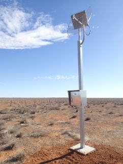
In 2013, the totalising rain gauges were replaced by tipping bucket gauges that record the time/date for each tip (representing 0.2mm rainfall) of the bucket. The data is summed daily and passed to UNSW via a radio and Telstra 3G network where it is displayed via the CWI NCRIS web site.
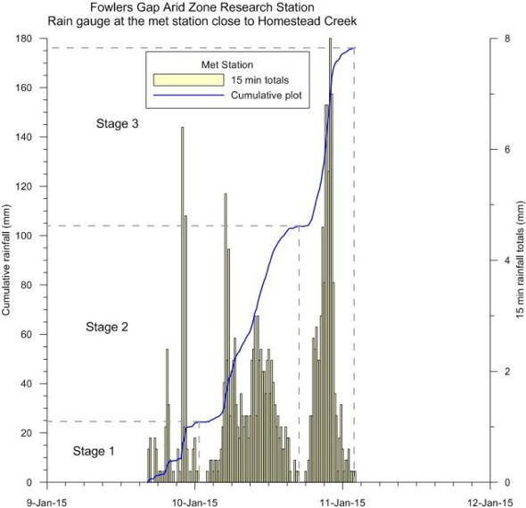
The distribution of rainfall during a storm event can be best depicted by constructing a cumulative rainfall plot over time. The above plot shows the event as recorded at the Met Station gauge.
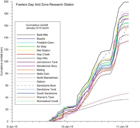
Cumulative distribution for all gauges. Problems are apparent with the data from Gap Hills and North Mandelman and illustrate clearly the necessity to check data after it is received. The three phases of the storm throughout the catchment are clearly seen. The variation in totals is also clearly shown indicating significant spatial variability.
Flooding was recorded by gauges and cameras.
At about 23:00 during the night of the 10th/11th, the flood reached a depth of approximately 4m and the cabling to the camera system was ripped out. The camera failed – but luckily, the level gauge continued to work.
The groundwater monitoring bores installed by the NCRIS scheme were positioned downstream from the rock bar visible in the gauge photograph above. The intention is to see how much groundwater recharge can occur from a major event like this. The groundwater level beneath the creek a few km downstream is in a perched aquifer at approximately 18m depth and in more permanent water at 70m depth. It will take a while before these bores are impacted and they are not being monitored over the network but will require a visit to download the data loggers.
The closer bores were certainly impacted!
The flood water rose above the top of the bore (GW273277) and poured down inside to perform a remote aquifer slug test. The bore, drilled to 5m, was previously dry.
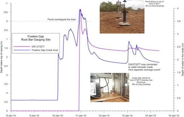
Water level in bore GW273277 before, during and after the rainfall event compared to level in Fowlers gap Creek. Before the event, the bore was dry.
Combining data sets provides a a clearer picture of the flood event showing how levels in Fowlers Gap Creek and the lake at Freislicht Dam on the Station changed in response to the measured rainfall.
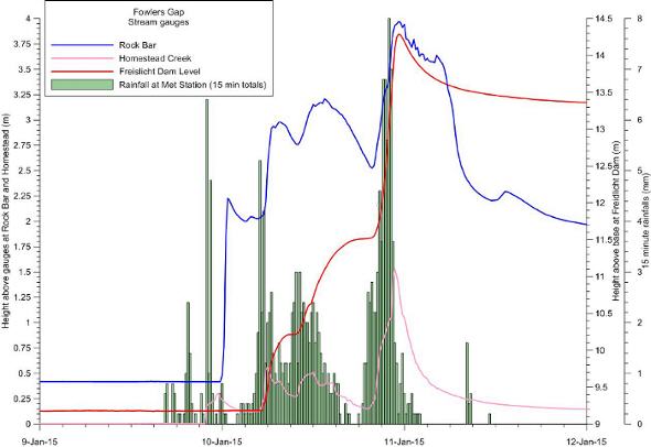 Cumulative data plot showing lake level at Freislicht Dam, rainfall, levels in Fowlers Gap Creek, Homestead Creek and the 15 minute rain totals.
CWI will continue to monitor the groundwater levels as the creek dries out to get a better idea of local groundwater recharge and use by the surrounding River Red Gums.
Groundwater level monitoring data recovered at the end of 2019 from Mystery Road at Breeza on the Liverpool Plains reveals a direct connection between the Gunnedah Formation unconsolidated sands and gravels and the underlying Permian coal measures. The connection is provided by the old deep channel of the Mooki River that cuts down into the coal measures. This is a crucial piece of evidence to be incorporated into groundwater models.

What are the effects of fire on water underground? Let’s think about what happens on the surface, and translate that to what is likely to happen to the subsurface.

The effects of tidal forces on groundwater might be less apparent to us than their effects on the ocean, but they’re just as important.

Dr Oliver Knox has brought together information from some of the industry’s researchers conducting work oncotton-producing soils.

Groundwater research at ANSTO has provided crucial information to support the management of finite groundwater resources appropriately and sustainably—answering questions about groundwater recharge, groundwater age and dynamics, the interaction between surface water and groundwater and salinisation.
Professor Andy Baker features in American Water Resources Association ‘Water Resources Impact’, September 2020 edition.
CWI’s network of researchers is widening - Welcome Taylor Coyne!

