Posted 16 October 2012
A cave entrance in the Wellington region. It has no relationship with the modern day landscape, suggesting it is not formed by modern-day downward movement of percolating waters.
Andy Baker
Despite the fact that karst regions are recognised as significant groundwater resources, the nature of groundwater flow paths in the unsaturated zone of such fractured rock is at present poorly understood.
Many traditional methods for constraining groundwater flow regimes in karst aquifers are focussed on the faster drainage components and are unable to inform on the smaller fracture or matrix-flow components of the system.
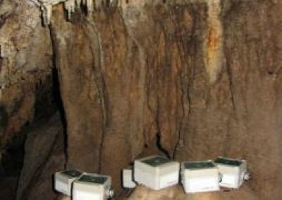
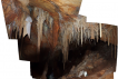
Caves however, offer a natural inception point to observe both the long term storage and the preferential movement of water through the unsaturated zone of such fractured carbonate rock by monitoring of drip rates of stalactites, soda straws and seepage from fractures/micro fissures that emerge in the cave ceiling.
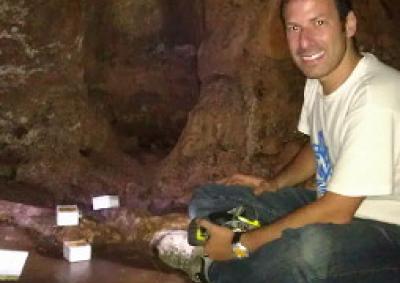
Connected Waters Initiative Research Centre team members have recently published infiltration data for Cathedral Cave, Wellington, in the centralwest New South Wales, with the paper available from the open-access International Journal of Speleology, and the raw data available here. The dataset is the largest spatial survey of automated cave drip rate monitoring published to date.
Our aim is to better understand both karst drip water hydrogeology and the relationship between drip hydrology and surface climate. Our research site, Cathedral Cave, is considered to have formed by upward dissolution of limestone by groundwater (Osborne, 2007), rather than the more conventional dissolution by downward movement of infiltration water. This hypogene (from ascending waters) formation process is arguably typical of caves in eastern Australia (Osborne, 2010), and our monitoring results are therefore the first investigation of infiltration in such a context.
Due to the large amount of data, the paper also utilises novel statistical and visualisation approaches. Using these, we investigate the relationships between drip behaviour and initial surface infiltration, the similarity amongst the drip rate time series, and the relationship between flow regimes and cave chamber morphology and lithology.
Our monitoring is on-going, and is supported by the Groundwater Education Investment Fund and the National Centre for Groundwater Research and Training. Wellington Council have kindly permitted access to Cathedral Cave, and our experiments can be seen during the tourist visit. We would welcome school group use of the data provided here. For further details, please contact Catherine Jex or Andy Baker.
References:
Osborne R.A.L., 2007. - Cathedral Cave, Wellington Caves, New South Wales, Australia. A multiphase, non-fluvial cave. Earth Surface Processes and Landforms, 32(14): 2075-2103.
Osborne, R.A.L., 2010. Rethinking eastern Australian caves. Geological Society, London, Special Publications, 346, 289-308.
Groundwater level monitoring data recovered at the end of 2019 from Mystery Road at Breeza on the Liverpool Plains reveals a direct connection between the Gunnedah Formation unconsolidated sands and gravels and the underlying Permian coal measures. The connection is provided by the old deep channel of the Mooki River that cuts down into the coal measures. This is a crucial piece of evidence to be incorporated into groundwater models.

What are the effects of fire on water underground? Let’s think about what happens on the surface, and translate that to what is likely to happen to the subsurface.

The effects of tidal forces on groundwater might be less apparent to us than their effects on the ocean, but they’re just as important.

Dr Oliver Knox has brought together information from some of the industry’s researchers conducting work oncotton-producing soils.

Groundwater research at ANSTO has provided crucial information to support the management of finite groundwater resources appropriately and sustainably—answering questions about groundwater recharge, groundwater age and dynamics, the interaction between surface water and groundwater and salinisation.
Professor Andy Baker features in American Water Resources Association ‘Water Resources Impact’, September 2020 edition.
CWI’s network of researchers is widening - Welcome Taylor Coyne!