Posted 22 June 2010

Stalagmites
Stalagmites are a type of speleothem. Speleothems are mineral deposits formed in caves, usually from calcite, and include stalactites and flowstones. They are widely recognised 'time capsules' of past climate and environmental change, and their study is a major area of palaeoclimate research.
Stalagmites have several characteristics that make them ideally suited to reconstructing past climates and environments.
First, they can be precisely dated using uranium series chronologies. Historically this has been achieved by methods that measure uranium and thorium in the samples such as thermal ionisation mass spectrometry (TIMS), and inductively coupled plasma mass spectrometry (ICP-MS). These techniques have obtained dates back to around 500,000 years before present with a precision of approximately 1% from a sample size of a few milligrams.
Most recently, uranium-lead ICP-MS dating has extended stalagmite records back to as far as 4 million years before present. Although other natural palaeoclimatic and palaeoenvironmental archives such as ice cores and marine sediments also provide data extending equally as far back in time, their chronologies are less precise. In fact, speleothems have recently been used to determine the timing of palaeoclimate records contained within ice cores.
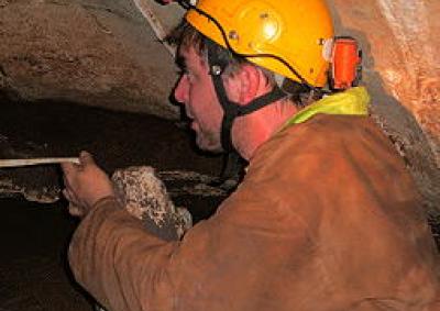
An additional advantage of stalagmites is that they often contain annual growth banding, providing greater chronological control. Usually, stalagmites are closed systems: any organic or inorganic material contained within the stalagmite is preserved from the time of deposition with negligible effects of post-depositional alteration. Therefore, tiny samples of materials retrieved from stalagmites can be used to extract more accurate records of past climates and environments. These materials usually include inorganic isotopes and trace elements, the proxies of choice of palaeoenvironmental and climate change.
The deposition rate of stalagmites is well-understood to be in the range of 0.01 to 0.5 mm per year, depending on climate and overlying soil cover. With the small (microgram to milligram) sample sizes used for state-of-art analytical techniques, palaeoclimate and palaeoenvironmental proxies can be obtained at seasonal to decadal timescales, depending on growth rate and proxy type.
Another useful characteristic of stalagmites is that they are found in many locations around the world. Around 22 million km2 of the Earth's surface is occupied by carbonate rocks and therefore has, or has the potential, for cave formation and stalagmite deposition. Many other palaeoclimatic and palaeoenvironmental proxies are found either at high latitudes (e.g. ice cores) or in the oceans (e.g. marine cores), often distant from regions where an understanding of climate and environmental change is important.
Furthermore, caves provide excellent locations for the preservation of stalagmites away from erosion or destruction by natural or human activity.
The combination of these factors has led to the recognition of the usefulness of speleothems for obtaining precisely dated records of past climate and environmental change on a variety of timescales.
Records of past climate or environmental change are obtained by measuring chemical indicators - or inorganic proxies - preserved within stalagmite calcium carbonate (CaCO3), such as stable isotopes of oxygen and carbon, and to a lesser extent, trace elements.
For example, researchers have been to identify changes in past vegetation through the analysis of the stable carbon isotope (δ13C) and have quantified past temperatures by measurement of the stable oxygen isotope (δ18O).
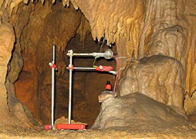
The various inorganic proxies have been shown to indicate palaeoenvironmental conditions differently, depending on the processes affecting stalagmite deposition. These processes are rapidly becoming more completely understood, and relate to the nature of hydrology of the limestone landscape (known as karst) and the transfer of water from the soil to the cave. Because each stalagmite is ultimately fed by a unique 'plumbing system', there is always the possibility of contingent variation related to factors unique to that drip. Therefore each individual stalagmite may have different sensitivities and thresholds to change. For this reason, there is a need to duplicate samples wherever possible, to account for unique hydrological factors for a given drip from changes affecting whole caves or different caves in a region.
Conditions at the surface and along the pathway taken by water on its way into a cave can affect the quantities of different proxies preserved within stalagmites in different ways. For example, δ13C levels can be reduced by processes that decrease the amount of dissolved carbon dioxide in water (or degassing) before it arrives in a cave, causing relatively high levels of heavier isotopes to be preserved. In warmer climates, evaporation can cause overrepresentation of heavier δ18O.
These processes that affect the chemistry of groundwater during transport can vary depending on climate. The effects of degassing and evaporation on proxies preserved in speleothems are characteristically better expressed during climatically dry intervals rather than wet periods.
Therefore, it is necessary to take a multi-proxy approach in order to determine whether any of these processes have affected the levels of different proxies. In some cases this can be achieved by identifying characteristic co-variations in proxies, such as δ13C versus δ18O, that can be attributed to evaporation. In others, characteristics of stalagmite shape or layering can be compared with theoretical expectations derived from functions of drip water chemistry and drip rate.
Comparison with modern climate and vegetation records has proven particularly useful in establishing the relationships between stalagmite inorganic proxies and surface climate and environment, and how well the inorganic proxy chemistry preserved in the stalagmites responds to change.
Although the historical focus has been on inorganic proxies within speleothems, they also contain organic materials. In particular, they include those derived from the overlying plants and soil, because the drip waters that formed the speleothems have passed through the soil en-route to the cave. In fact, the vegetation and soil overlying the cave have been known to modify inorganic atmospheric signals to a varying extent and generate new signals (e.g., δ13C and soil colloid bound trace elements). While these can interfere with inorganic proxy work, they clearly demonstrate the potential for organic proxies to be transferred from the soil to the speleothems.
Combining an understanding of how climatic and environmental signals are transferred from the surface into speleothems with ways of calibrating these chemical proxies allows researchers to obtain unique records of past climate and environment.
Groundwater level monitoring data recovered at the end of 2019 from Mystery Road at Breeza on the Liverpool Plains reveals a direct connection between the Gunnedah Formation unconsolidated sands and gravels and the underlying Permian coal measures. The connection is provided by the old deep channel of the Mooki River that cuts down into the coal measures. This is a crucial piece of evidence to be incorporated into groundwater models.

What are the effects of fire on water underground? Let’s think about what happens on the surface, and translate that to what is likely to happen to the subsurface.

The effects of tidal forces on groundwater might be less apparent to us than their effects on the ocean, but they’re just as important.

Dr Oliver Knox has brought together information from some of the industry’s researchers conducting work oncotton-producing soils.

Groundwater research at ANSTO has provided crucial information to support the management of finite groundwater resources appropriately and sustainably—answering questions about groundwater recharge, groundwater age and dynamics, the interaction between surface water and groundwater and salinisation.

Professor Andy Baker features in American Water Resources Association ‘Water Resources Impact’, September 2020 edition.
CWI’s network of researchers is widening - Welcome Taylor Coyne!